


Ontology-Based Photogrammetry Survey for Medieval Archaeology: the case study of Shawbak, Jordan
Pierre Drap, Odile Papini, Elisa Pruno, Guido Vannini
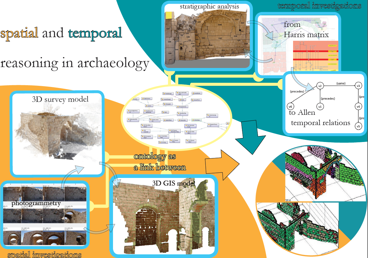
We present here certain reflections concerning an interdisciplinary project between medieval archaeologists from the University of Florence (Italy) and computer science researchers from CNRS, National Center for Scientific Research, (France), aiming towards a connection between 3D spatial representation and archaeological knowledge. We try to develop an integrated system for archaeological 3D survey and all other types of archaeological data and knowledge by incorporating observable (material) and non-graphic (interpretive) data. Survey plays a central role, since it is both a metric representation of the archaeological site and, to a wider extent, an interpretation of it (being also a common basis for communication between the two teams). More specifically, 3D survey is crucial, allowing archaeologists to connect actual spatial assets to the stratigraphic formation processes (i.e., to the archaeological time) and to translate spatial observations into historical interpretation of the site. It is well known that laser scanner, photogrammetry and computer vision are very useful tools for archaeologists, although the integration of the representation of space, as well as archaeological time has not yet found a methodological standard of reference. We propose a common formalism for describing photogrammetric survey and archaeological knowledge stemming from ontologies: indeed, ontologies are fully used to model and store 3D data and archaeological knowledge. We equip this formalism with a qualitative representation of time, starting from archaeological stratigraphy. Stratigraphic analyses (both of excavated deposits and of upstanding structures) are closely related to Edward Cecil Harris’s theory of the “Unit of Stratigraphication” (referred to as “US”, while a stratigraphic unit of an upstanding structure Unita Stratigrafica Murale, in Italian, will be referred to as “USM”). Every US is connected to the others by geometric, topological and, eventually, temporal links, and these are recorded by the 3D photogrammetric survey. However, the limitations of the Harris matrix approach led us to use another formalism for representing stratigraphic relationships, namely Qualitative Constraints Networks (QCN), which was successfully used in the domain of knowledge representation and reasoning in artificial intelligence for representing temporal relations.
Drap, P., Papini, O., Pruno, E., Nucciotti, M., & Vannini, G. (2017). Ontology-Based Photogrammetry Survey for Medieval Archaeology: Toward a 3D Geographic Information System (GIS). Geosciences, 7(4), 93.